Climate Change Initiative (CCI) is a joint ESA and EU initiative. The CCI aims at exploiting the historical archives of ESA and Third Party Mission satellites to address the requirements for a set of long term and consistent Essential Climate Variables (ECV). The variables were defined by the Global Climate Observing System (GCOS) to support the work of the UN Framework Convention on Climate Change (UNFCCC) and the International Panel on Climate Change (IPCC).
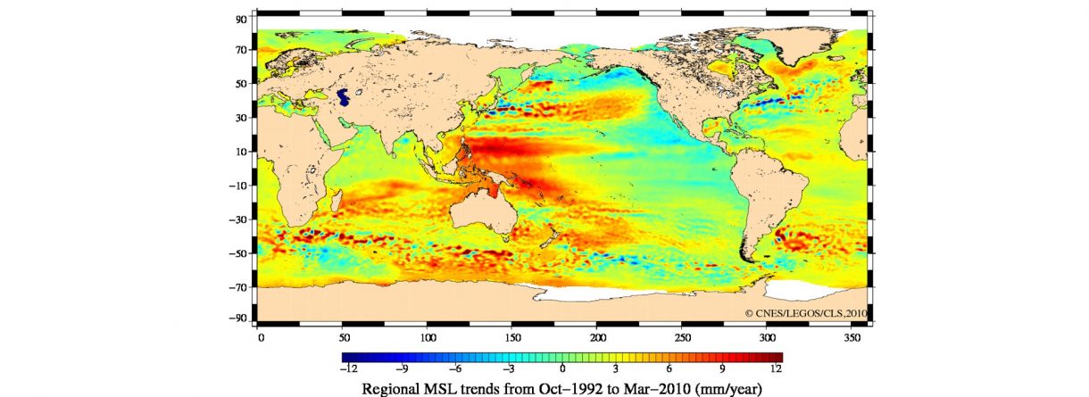
There are 44 ECVs plus soil moisture recognised as an emerging ECV. Sea Level being one of the 8 variables of the oceanic surface, is one of the 10 selected for the first round of ESA projects. Sea level is a very sensitive index of climate change and variability.
Modification of the land hydrological cycle as a result of climate variability and direct human-induced forcing leads to increased or decreased runoff, and ultimately to sea-level change. As a result, local and regional climate changes may affect sea level globally. While tide gauge sea-level data constitute one of the few long historical ocean climate time series, to monitor global sea level change and to put regionally observed changes into the global context, ocean surface topography measurements by satellite altimeters are essential. Jointly with the tide gauge network, continued operational measurements of satellite altimetry (ERS, Topex, Jason series, EnviSat…) complete the sea-level network. Together they represent an integrated strategy for monitoring of sea-level variability and change globally and on regional scale.
Visit ESA webpage